May 14, 2023
#9: Sorting out Ownership Questions – Digging into Financialization through Land Titles Data
André Magnan is a rural sociologist with a longstanding research interest in agricultural restructuring. Annette Aurélie Desmarais is a geographer, leading scholar of food sovereignty, and former farmer. Our research collaboration on prairie farmland dates to 2014, when, along with colleagues, we piloted a method for using land titles data to get to the bottom of a seemingly simple question: Who owns the land? We launched this collaboration because of growing media attention and anecdotal reports about large-scale investor purchases of farmland in the province of Saskatchewan, Canada’s top grains and oilseeds producer and exporter. In this piece, we reveal some of the political, financial, and methodological hurdles encountered in obtaining and using land titles data during a multi-year study of changing farmland ownership patterns on the Canadian prairies.
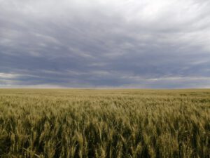
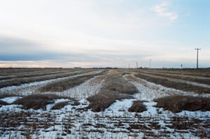
Grain field in Saskatchewan. Source: Diane Kuefelt.
Piloting the use of land titles data in land ownership research
We first piloted our methodology for measuring land ownership change by focusing on three Rural Municipalities (RMs) in Saskatchewan [1]. With the complete set of land titles for the province in hand, we were able to identify prominent investors and the RMs with the most investor purchases. We combined this with other methods including pouring over paper RM maps (which list landowners) and qualitative interviews with locals to provide a snapshot of changing land ownership over time at the local level. Land titles data also allowed us to calculate the concentration of land ownership in specific rural municipalities using the CLO4, a measure that captures the ownership stake of the four largest landowners in a particular jurisdiction.The power of the land titles data was that they were available in electronic format, allowing us to easily filter and sort results, and could be combined with geospatial data using Geographical Information Systems software to produce highly sophisticated maps. We later expanded our research by using land titles data to analyze ownership changes from 2002 to 2014 in the entire province. This method allowed us, with quite a high accuracy, to identify investor owners of farmland, put a precise number on their holdings, and capture dramatic ownership changes following the liberalization of land ownership rules in 2002 (see maps below) [2].
In 2017, with funding from the Social Sciences and Humanities Research Council of Canada, we expanded our research to study farmland consolidation, concentration and financialization in the three prairie provinces – Alberta, Manitoba, and Saskatchewan – a region that encompasses 70% of Canada’s agricultural land. Since we had obtained Saskatchewan land titles data relatively easily and at an affordable price, we anticipated similar experiences in accessing the data for the other provinces. Our expectations were dashed as we met a variety of political and financial hurdles in Alberta and Manitoba.
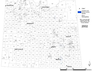
Locations of parcels owned by investors and farmer/investor hybrids in blue, 2002. Map prepared by Sarina Gersher using ArcGIS and source map data from Information Services Corporation (Including Sask Grid, Rural Municipalities Boundary Overlay, Sask Surface Cadastral, and Ownership Datasets). Source: map data utilized and reproduced with the permission of Information Services Corporation. Additional GIS data from Natural Resources Canada and GeoBase.
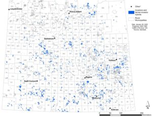
Locations of parcels owned by investors and farmer/investor hybrids in blue, 2018. Map prepared by Sarina Gersher using ArcGIS and source map data from Information Services Corporation (Including Sask Grid, Rural Municipalities Boundary Overlay, Sask Surface Cadastral, and Ownership Datasets). Source: map data utilized and reproduced with the permission of Information Services Corporation. Additional GIS data from Natural Resources Canada and GeoBase.
The political economy of land titles data
In 2014, we paid just under $1400 CAD for delivery of the land titles data for Saskatchewan from Information Services Corporation (ISC), the province’s semi-public land titling agency. Negotiating an agreement with ISC was straightforward and quick, and the data itself was provided free of cost for educational purposes. We then easily secured the data once again from ISC to track changes in land ownership from 2014 to 2018. Conversely, we faced two main obstacles in our attempts to obtain land titles data in the neighbouring province of Alberta, through its Land Titles Office (LTO). First, the cost was simply prohibitive. A representative of Altalis (an agency responsible for making the province’s data more “accessible, accurate and affordable”) indicated that they could provide the data under a special education/research license for a “reduced cost” of approximately $48,000 CAD. Secondly, Altalis clarified that the data could not include the landowners’ names.In Manitoba, the story of obtaining land titles data is something of an epic. We will spare you the bureaucratic details, but suffice it to say that we made an initial request back in 2014 and it was only in March 2023 that we finally secured an agreement with the Government of Manitoba and Teranet, the transnational company responsible for managing land titles data for the province. The main roadblocks here included a change of personnel of those responsible, inconsistency in the information from the Government and Teranet, and extraordinarily long delays in communicating with government lawyers.
As the difficulty of obtaining these data became clear, one of our graduate students wrote her Master’s thesis on the political economy of land titling. Her fascinating thesis documents the gradual commercialization and privatization of land titling, culminating in a patchwork of different systems and approaches across Canada. Despite the differences, the systems cater primarily to real estate professionals and lawyers who regularly access land titles for real estate transactions, making public interest access and use of the data difficult, and in some cases impossible. Interestingly, the relative openness or closedness of the various land titling agencies does not map neatly onto their degree of privatization. For instance, it was prohibitively expensive to obtain data from the predominantly public land titling agency in Alberta, whereas the semi-private agency in Saskatchewan charged a minimal fee for data preparation and delivery. In the case of Manitoba, where data management has been more fully privatized (i.e. to Teranet), we are not being charged a cost, but this may well be due to the fact that it has taken so long to negotiate the data agreement.
Our experiences highlight the ‘data politics’ of land titles information. In principle, these are public records, but in practice, there are significant financial, bureaucratic and ideological obstacles to accessing them. And, even when one is lucky enough to succeed in getting the data, governments are pitting landowner privacy rights against public interest concerns. Neither Manitoba nor Alberta permit the disclosure of landowner names, making it impossible for us to reach our initial research goal of demonstrating who owns what, how much and where in the province, as we did in Saskatchewan (below).
Nevertheless, our team did conduct qualitative fieldwork in all three provinces, providing rich on-the-ground accounts of changing land ownership. But there is no doubt that our research is most powerful when we can combine land titles analysis, mapping, and qualitative research.
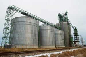
Cargill grain storage facilities by railroad tracks in rural Alberta. Source: Katherine Aske.
Working with land titles data: What do they reveal and what do they obscure?
As useful as it has been to work with land titles data when we’ve been able to access them, we want to reflect here on both the power and the limitations of this approach. There are some methodological challenges in trying to make sense of these very granular data. Typically, a rural land titles record contains the following information: name of the title holder, legal description of the land (including its geographical coordinates), the size of the land parcel, and the rural municipality in which it is located. Some of the challenges of working with these data include the huge volume of information and data errors such as punctuation, spelling or abbreviation mistakes that had to be corrected to make sense of the data. We used filtering, sorting, and finding and replacing tools to deal with these issues.Furthermore, rural land ownership is highly fragmented and complex. For instance, some title holders are numbered companies, obscuring the identity of individual or corporate shareholders. To crack this ‘black box’, we conducted Corporate Registry searches on numbered companies that we had flagged as potential investors. These searches revealed valuable information about these entities, but involved extra steps and costs. In some highly complex cases, it was not possible to fully trace the intricate corporate structures behind a particular titleholder.
It also quickly became clear to us that some entities and farm families own land under several unique title names. Sometimes the connections are obvious from a reading of the land titles data, but not always. We used conservative criteria in aggregating ownership stakes of connected entities, meaning that we may have missed certain cases where seemingly separate owners are in fact a single entity. These challenges highlight for us the importance of triangulating land titles research with other sources of information. In certain cases, local information obtained from qualitative interviews helped make sense of the highly abstract, objective land titles data. In other cases, we used media reporting and websites to connect specific companies or individuals with land titles records.
Land titles research is an invaluable way of deciphering ‘land relations’, but it offers a particular way of seeing land that has its limitations. For one, it captures legal ownership at a given ‘point in time’, and can only be used to track land ownership change when comparing distinct moments. In addition, the name on a title reveals nothing, in and of itself, about relationships of credit, debt, and subsidiarity that characterize some complex corporate holdings [3]. There are, of course, larger questions about the extent to which legal ownership translates to effective control over land. Who owns the land on paper may tell us little about how the land is managed, who farms it, and to what extent the owners are connected to a place or community. As we learned in our research, the largest farms in Saskatchewan now combine owned land with vast amounts of rented land. For instance, our land titles analysis revealed that Kambeitz Farms owns just under 20 000 acres of farmland, but according to its own website, its total farming footprint is actually 55 000 acres [4]. This pattern seems quite common among Saskatchewan mega-farms, some of which partner with investor-owners to reach massive scale. Thus, pinpointing the amount of land owned by a particular large farming enterprise only goes so far in understanding the true scale of their operation. As industrial farms get larger, the land ownership/rental arrangements underlying them get only more complex, and consequently so must researchers’ methods.
Canola crop left unharvested in 2019 due to early snowfall and rain. This was the fifth difficult harvest year in Alberta. Source: Katherine Aske.
[1] Desmarais AA, Qualman D, Magnan A, et al. (2015) Land grabbing and land concentration: Mapping changing patterns of farmland ownership in three rural municipalities in Saskatchewan, Canada. Canadian Food Studies/La Revue canadienne des études sur l'alimentation 2(1): 16-47. [2] Desmarais AA, Qualman D, Magnan A, et al. (2017). Investor ownership or social investment? Changing farmland ownership in Saskatchewan, Canada. Agriculture and Human Values 34(1), 149-166. [3] Ashwood L, Canfield J, Fairbairn M, et al. (2022) What owns the land: The corporate organization of farmland investment. The Journal of Peasant Studies 49(2): 233-262. [4] Magnan A, Davidson M and Desmarais AA (2022) ‘They call it progress, but we don’t see it as progress’: farm consolidation and land concentration in Saskatchewan, Canada. Agriculture and Human Values 40(1): 277-290.